Lookout Fire Update: August 17, 2023, 3:30 p.m.
Quick Facts-
Size: 4,271 acres
Containment: 0%
Start Date: August 5, 2023
Point of origin: 3 miles North of McKenzie Bridge, OR
LOOKOUT FIRE ON MCKENZIE HWY CAUSES LEVEL 1 EVACUATION ALERT
The Lookout Fire burning in Lane County near McKenzie Bridge along Highway 126 is currently at 4,271 acres. It is burning just south of the Linn County line shared with Lane County. Both Sheriff’s Offices are coordinating efforts with Lookout Fire Command and the Incident Management Team.
While northeast of the Lookout Fire by several miles, Linn County Sheriff Michelle Duncan is concerned for campers, hikers and visitors to the Trail Bridge Reservoir, Smith Reservoir, and Tamolitch Falls area. Out of an abundance of caution, Sheriff Duncan, working in coordination with Lane County Sheriff Cliff Harold, are issuing a Level 1 (BE READY) evacuation alert.
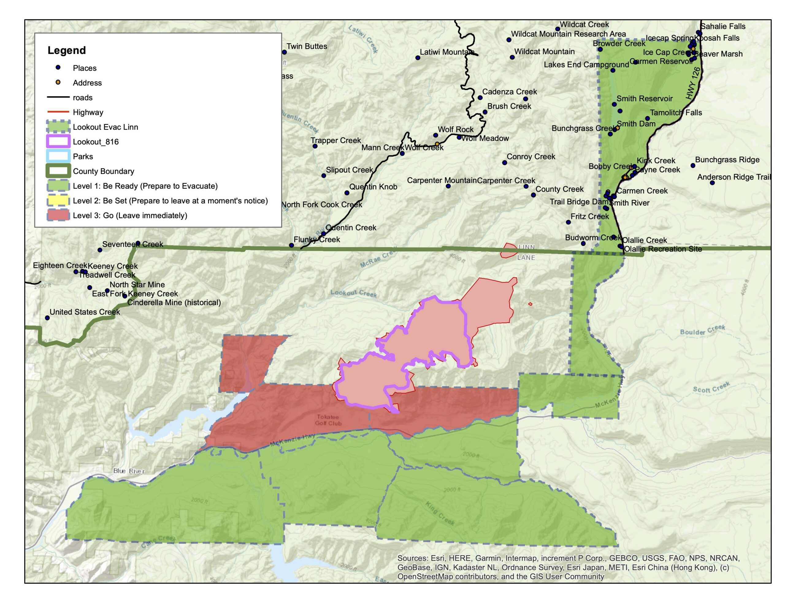 The following areas are within a LEVEL 1 (BE READY) Evacuation Alert zone: Beginning on Highway 126 just north of Ice Cap Campground, west to include all of Smith Reservoir (including Lakes End Campground). Then extending south between Lakes End Campground and Highway 126, to the McKenzie Bridge/Frissell Boat Launch. Refer to the map located at http://tinyurl.com/LookoutFire and the attached map image.
Trail Bridge Reservoir, Smith Reservoir, and Tamolitch Falls (Blue Pool) are highly recreated areas of the McKenzie River Forest Service District. However, cell phone reception is weak or nonexistent in the area. This presents a danger to any persons using the areas within the listed LEVEL 1 (BE READY) zone. While the areas remain open, persons visiting the LEVEL 1 area should stay alert and prepared, as evacuation levels can change with fire conditions quickly and alerts may not be able to be delivered to cell phones in the area.
Much of the area included in this Level 1 (BE READY) evacuation alert is already part of a U.S. Forest Service Emergency Closure. By this declaration, no persons are to be on the roadways or trails within the closure area, or enter or remain on the National Forest Service lands covered by the closure.
For more information on evacuations, visit https://www.linnsheriff.org/ and https://tinyurl.com/LinnWileyFire.
Important Links:
Lookout Fire Map: https://tinyurl.com/LookoutFire
Lookout Fire 2023 Facebook: https://www.facebook.com/LookoutFire2023
Air & Smoke Map: https://fire.airnow.gov/
Willamette National Forest Facebook: https://www.facebook.com/willamettenf
Fire Closures Map: Willamette National Forest https://www.fs.usda.gov/detail/willamette/alerts-notices/?cid=fseprd552029