Lookout Fire Update: August 23, 2023, 12:00 p.m.
Quick Facts-
Size: 13,207 acres
Start Date: August 5, 2023
Cause: Lightning
Containment: 6%
Point of origin: 3 miles North of McKenzie Bridge, OR
Total personnel: 1,213
Resources: 72 engines | 23 crews | 14 bulldozers | 31 water tenders | 11 masticators | 6 helicopters
EVACUATION LEVEL INCREASES DUE TO LOOKOUT FIRE
The Lookout Fire in the area of Highway 126, burning in both Lane County and Linn County is currently at 13,207 acres. A large Incident Command staff is in constant conversations with both Sheriff’s Offices, who are coordinating evacuation levels, closures, and public information efforts.
The Lookout Fire behavior is currently threatening popular recreation areas in southeast Linn County. Linn County Sheriff Michelle Duncan is concerned for campers, hikers and visitors to the areas of Olallie Campground, Trail Bridge Reservoir & Campground, Smith Reservoir & Campgrounds, Tamolitch Falls (Blue Pool), Sahalie Falls, Clear Lake & Campground, and Fish Lake.
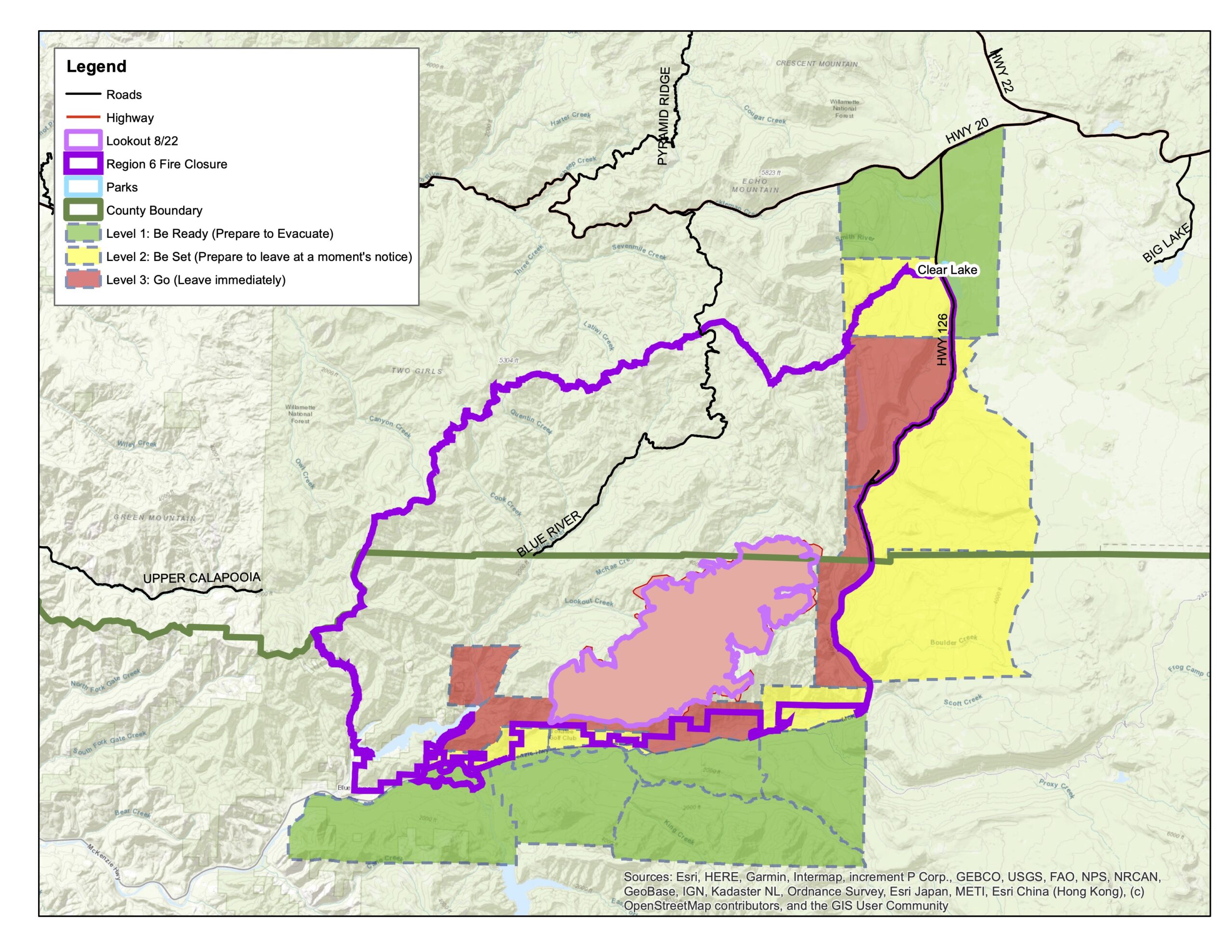 LEVEL 3: GO NOW Evacuation Zone
Sheriff Duncan is ordering an expansion of the existing LEVEL 3 (GO NOW) Evacuation Order. A LEVEL 3 (GO NOW) Evacuation Order now extends from Olallie Campground and the Linn County line, north and west of Highway 126, extending north to Ice Cap Campground and Trailhead at Carmen Reservoir, then west to encompass Lakes End Campground and trail system at Smith Reservoir. Tamolitch Falls/Blue Pool is also within this LEVEL 3 (GO NOW) Evacuation Zone. Refer to the map located at http://tinyurl.com/LookoutFire and the attached map image.
Danger is current or imminent and you should evacuate now. If you choose to ignore this notice, emergency services may not be able to assist you further. DO NOT DELAY leaving to gather items or protect your home. THIS WILL BE THE LAST NOTICE YOU RECEIVE. Entry to evacuated areas may be denied until it is safe.
LEVEL 2: BE SET Evacuation Zone
Sheriff Duncan is ordering a LEVEL 2 (BE SET) Evacuation Order for the areas of Ice Cap Campground and Trailhead at Carmen Reservoir, north to where Ikenick Creek and Highway 126 intersect, and extending to the east in line with other evacuation boundaries enacted, and west along Highway 126. Refer to the map located at http://tinyurl.com/LookoutFireand the attached map image.
All areas within the LEVEL 3 (GO NOW) Evacuation Order, and nearly all of the LEVEL 2 (BE SET) Evacuation Order, are already closed to all persons, vehicles, and recreation by declaration of a U.S. Forest Service Emergency Closure order. By this order, no persons are to be on the roadways or trails within the closure area, or enter or remain on the National Forest Service lands covered by the closure. Refer to the map located at http://tinyurl.com/LookoutFire and the attached map image.
LEVEL 1: BE READY Evacuation Preparedness Alert
Sheriff Duncan is continuing the previous LEVEL 1 (BE READY) preparedness evacuation level. That includes the areas north of where Ikenick Creek and Highway 126 intersect, extending east to the Willamette National Forest boundary, and north in line with Highway 20. This includes all areas around Clear Lake, and Clear Lake Campground, as well as Fish Lake and Campground. Refer to the map located at http://tinyurl.com/LookoutFire and the attached map image.
Highway 126 remains open to all vehicle traffic. Anyone traveling the area should proceed with caution, and yield to all emergency vehicles. Travelers are advised to check www.TripCheck.com for the latest in roadway information.
All areas mentioned have poor or nonexistent cell phone reception. This presents a danger to any persons using the areas within the listed zone. While LEVEL 1 and LEVEL 2 areas remain open, persons visiting should stay alert and prepared, as evacuation levels can change with fire conditions quickly, and alerts may not be able to be delivered to cell phones in the area.
For more information on evacuations, visit https://www.linnsheriff.org/ and @LinnSheriff.
The Lane County Sheriff’s Office has also issued evacuation alerts. Citizens are encouraged to visit https://lanecounty.org/lookoutfire and their Facebook page at @LaneCountySheriffsOffice
Important Links:
Lookout Fire Map: https://tinyurl.com/LookoutFire
Lookout Fire 2023 Facebook: https://www.facebook.com/LookoutFire2023
Air & Smoke Map: https://fire.airnow.gov/
Willamette National Forest Facebook: https://www.facebook.com/willamettenf
Fire Closures Map: Willamette National Forest https://www.fs.usda.gov/detail/willamette/alerts-notices/?cid=fseprd552029